 Chief Finance Officer (CFO) Kristina Pickel |
Budget Season Kicks Off with Annual Budget Memo.
As we transition into budget season, the City of Red Bank has officially begun the process of preparing its annual budget. This important phase was kicked off with the release of the annual budget memo from the Comptroller’s Office, providing guidance and key financial priorities for the upcoming fiscal year. With this foundation in place, the Finance Department is already hard at work ensuring that the budget is developed efficiently and in alignment with the City's and Commission's goals. The team remains on track for a timely completion, with a focus on responsible financial planning and transparency. Throughout the budget process, there will be opportunities for department heads, elected officials, and community stakeholders to provide input before final approval. The City is committed to maintaining fiscal responsibility while continuing to invest in services and infrastructure that benefit our residents. Stay tuned for updates as we move forward in this year’s budget cycle! - City of Red Bank CFO, Kristina Pickel ___________________________________________________________________________________________
|
|
|
|
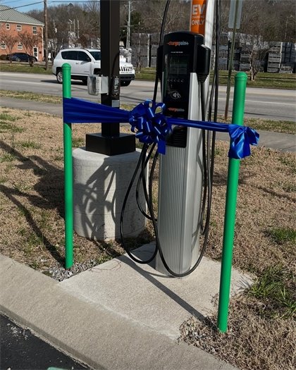
Ribbon Cutting to Celebrate the EV Charging Stations.
On February 18th at 4 PM, we held a ribbon cutting ceremony to celebrate the installation of EV Charging Stations, made possible with help from Dr. Chen at Tennessee Tech University. This EV charging station is one of two locations, including the police department parking lot and Kid’s Corner Park. Both spots are within walking distance of restaurants and shopping/convenience stores. Public Works aims to encourage residents and fellow Chattanoogans to try out the stations. You can simply walk up to the station, connect your debit/credit card with your cell phone, and plug in the charger to your car. We hope to install superchargers in the near future through a grant from TTU that assists rural communities with access to charging stations, benefiting our residents in Red Bank. |
|
|
|
|
|
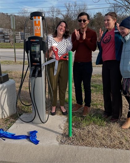 Photographed from Left to Right: Mayor Stefanie Dalton, Dr. Pingen Chen, Vice Mayor Hollie Berry, Commissioner Jamie Fairbanks-Harvey |
|
|
|
___________________________________________________________________________________________ |
|
|
|
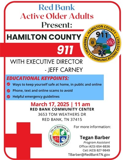
Buzzed Driving Is Drunk Driving: Make a Plan Before St. Patrick’s Day Festivities Begin
Red Bank, Tennessee — St. Patrick’s Day 2025 celebrations will take place across the country on and around Monday, March 17th. The U.S. Department of Transportation’s National Highway Traffic Safety Administration (NHTSA) urges drivers to remember that drinking and driving is deadly and never an option. Join NHTSA and the Red Bank Police Department in sharing this message: Buzzed Driving Is Drunk Driving. Every year, alcohol-impaired driving casts a shadow over the festive spirit of St. Patrick’s Day by taking the lives of community and family members across America. According to NHTSA, 38% (290) of the traffic fatalities that occurred between 2018-2022, during the St. Patrick’s Day holidays (from 6 p.m. March 16 thru 5:59 a.m. March 18) involved drunk drivers. In 2022 alone, there were 74 drunk-driving fatalities during the St. Patrick’s Day holiday, of which 49 involved drivers with a blood alcohol level of almost twice the legal limit (.15+ BAC). In 2022 drivers ages 21-34 (34%) were the age group most involved in alcohol-impaired-driving fatalities during this holiday, followed by drivers under 21 (30%). The rates of passenger car drivers and motorcyclists involved in these fatal drunk-driving crashes were 34% and 41%, respectively.
|
|
|
|
|
|
“Embracing St. Patrick’s Day and its traditions is one thing; engaging in the deadly behavior that is drinking and driving is another. Feeling buzzed and getting behind the wheel puts lives at risk,” reminds Sgt. Rusty Aalberg. As law enforcement officers, we witness firsthand the devastation and loss caused by alcohol-impaired driving, along with the lasting pain it inflicts on families, friends, and entire communities. We’re partnering with NHTSA to share the reminder that Buzzed Driving Is Drunk Driving. Drinking and driving is not an option, but making sure someone sober will be behind the wheel is,” Sgt. Aalberg said. Drivers should be safe during St. Patrick’s Day by planning ahead if they intend to drink. They shouldn’t wait until after drinking to plan how to get somewhere. Alcohol impairment clouds a person’s judgment. Drivers should secure a designated sober driver or call a taxi or rideshare for a sober ride home. If a driver finds they are unable to drive, they should give their keys to a sober driver so that person can get them home safely. When a friend has been drinking and is considering driving, friends should be proactive — take away the keys and help them get a sober ride home. If anyone spots a drunk driver, contact local law enforcement. Drive 100% sober, because Buzzed Driving Is Drunk Driving. For more information on impaired driving, visit www.nhtsa.gov/risky-driving/drunk-driving. ___________________________________________________________________________________________ |
|
|
|
|
|
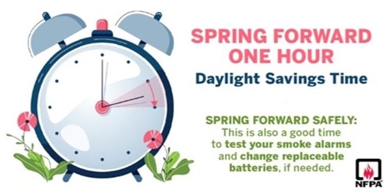
Daylight Saving Time is Sunday March 9th, 2025, which means we spring forward one hour. Spring forward is also a good time to Change Your Clock Change Your Batteries. Communities nationwide witness tragic home fire deaths each year. Non-working smoke alarms rob residents of the protective benefits home fire safety devices were designed to provide. The most commonly cited cause of non-working smoke alarms: worn or missing batteries. Changing smoke alarm batteries at least twice per year is one of the simplest, most effective ways to reduce these tragic deaths and injuries. In fact, working smoke alarms nearly cut in half the risk of dying in a home fire. Additionally, the International Association of Fire Chiefs recommends replacing your smoke alarms every ten years. To save lives and prevent needless injuries, the Red Bank Fire Department has joined the “Change Your Clock, Change Your Battery” campaign. The program urges all Americans to adopt a simple, lifesaving habit: changing smoke alarm and carbon monoxide detector batteries when changing clocks to daylight savings time. The peak time for home fire fatalities is between 10 p.m. and 6 a.m. when most families are sleeping. Smoke alarm maintenance is a simple, effective way to reduce home fire deaths. A working smoke alarm can give your family the extra seconds you need to get out of a home fire safely. In addition, the Red Bank Fire Department recommends residents use the “extra” hour they save from the time change to test smoke alarms and carbon monoxide detectors by pushing the test button, planning “two ways out” and practicing escape routes with the entire family. Families should also prepare a fire safety kit that includes working flashlights and fresh batteries. ___________________________________________________________________________________________
|
|
|
|
|
|
|
|
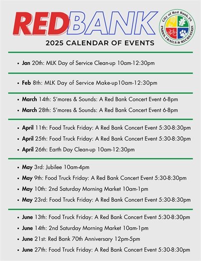
Exciting News for Music Lovers! Join us for "S'mores & Sounds - a Red Bank Concert Series", an unforgettable musical experience where melodies meet marshmallows! Gather with friends and family under the stars, enjoy live performances by talented artists, and enjoy FREE s'mores by the fire. It's the perfect blend of sweet treats and sweet tunes! We look forward to seeing you there! |
|
|
|
|
|
___________________________________________________________________________________________ |
|
|
|
|
|
|
|
|
|
|
|
|
|
___________________________________________________________________________________________ |
|
|
|
|
|
___________________________________________________________________________________________ |
|
|
|
|
|
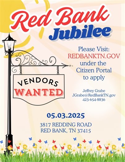
VENDORS WANTED! Join us for the Red Bank Jubilee on May 3, 2025, and showcase your products at this exciting community event! Location: 3817 Redding Road, Red Bank, TN 37415 Time: 10 AM – 4 PM Want to be a vendor? Apply now! Visit the link located in the comment section below to sign up. For more info, contact Jeffrey Grabe at JGrabe@RedBankTN.gov or 423-654-8836. Don’t miss this chance to connect with the community and grow your business! _____________________________________________________________________________________ |
|
|
|
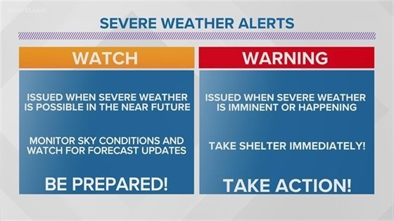
Watch vs Warning: Severe Weather Awareness.
It's that time of the year again, the flowers start blooming, the trees start budding, the smell of fresh cut grass is in the air, and the possibility of Severe Weather is right around the corner. In this month’s newsletter we will talk about the differences between a watch and a warning as we also provide some important safety tips for you to keep in mind in the event of severe weather. Severe Thunderstorm Watch The Storm Prediction Center (SPC), located in Norman, Oklahoma, plays a crucial role in monitoring and forecasting severe weather events. Let’s break down what a severe thunderstorm watch entails: Definition: A severe thunderstorm watch outlines an area where an organized threat of severe thunderstorms is expected generally during a three- to six-hour period. It serves as an early warning for potentially hazardous weather conditions. Issuance Process: Consultation: Before issuing a severe thunderstorm watch, the SPC collaborates with local National Weather Service Forecast Offices (NWFOs). They discuss the current weather situation and assess the likelihood of severe thunderstorms. Preliminary Watch: The SPC issues a preliminary Severe Thunderstorm Watch, which provides a heads-up to the affected NWFO. Adjustment and Public Issuance: The NWFO adjusts the watch based on local conditions and then issues it to the public via a severe weather statement. Watch Duration: Severe thunderstorm watches typically last for 4 to 8 hours and are issued well in advance of the actual occurrence of severe weather. Purpose: During the watch, the NWFO keeps the public informed about the evolving weather situation within the designated area. They provide updates and notify when the watch has expired or been canceled. Analogy: Think of a severe thunderstorm watch like preparing a taco dinner. You have all the ingredients (atmospheric conditions) necessary to produce a severe thunderstorm, but just like you’re not ready to start cooking tacos immediately, Mother Nature may not be ready to unleash the storm yet. Remember, a severe thunderstorm watch is a proactive measure to keep people informed and prepared for potential severe weather impacts.
|
|
|
|
|
|
Severe Thunderstorm Warning A severe thunderstorm warning is a critical alert issued by your local National Weather Service Forecast Office (NWFO) when specific conditions are met. Let’s break it down: Criteria for Issuance: Radar Indication: The warning is triggered when a severe thunderstorm is indicated by radar. Spotter Reports: It can also be issued based on spotter reports of a thunderstorm producing hail one inch or larger in diameter and/or winds equal to or exceeding fifty-eight (58) miles per hour. Immediate Action: When this warning is issued, people in the affected area should seek shelter immediately. Tornado Risk: Severe thunderstorms have the potential to produce tornadoes, sometimes with little or no warning. Lightning Frequency: Unlike lightning frequency, which is not a criterion for issuing this warning, the focus is on other severe weather aspects. Duration: Severe thunderstorm warnings typically last for one hour and can be issued independently, even without a prior severe thunderstorm watch. Information Included: The warning specifies where the storm is located. It identifies the towns that will be affected by the severe thunderstorm. The primary threat associated with the storm (e.g., hail, strong winds) is communicated. Additional Considerations: If the severe thunderstorm also causes torrential rains, the warning may be combined with a Flash Flood Warning. After issuance, the NWFO provides periodic updates through severe weather statements, keeping the public informed about the storm’s status. Now, all the ingredients are in place, and Mother Nature is now cooking up the storm! |
|
|
|
Tornado Watch A tornado watch, similar to a severe thunderstorm watch, is issued by the Storm Prediction Center (SPC) in Norman, Oklahoma. Here’s how it works: Consultation: The SPC communicates with the affected local National Weather Forecast Office (NWFO). They discuss the current weather situation and share their insights. Preliminary Watch: The SPC issues a preliminary tornado watch. Adjustment and Public Issuance: The NWFO adjusts the watch based on local conditions and then issues it to the public via a severe weather statement. Watch Area: During the watch, the NWFO keeps the public informed about the weather conditions within the designated area. Expiration or Cancellation: The NWFO notifies when the watch has expired or been canceled. |
|
|
|
|
|
Tornado Warning A tornado warning is a critical alert issued when a tornado is either indicated by radar or reported by a spotter. Here’s what you need to know: Immediate Action: If you’re in the affected area, seek safe shelter immediately. Duration: Tornado warnings typically last for around 30 minutes. No Watch Required: Unlike a tornado watch, a warning can be issued without a prior tornado watch being in effect. Tornado Facts: Timing: Tornadoes tend to strike during spring and summer months, often between 3 and 9 p.m., but they can occur at any time. Sound: A tornado sounds like the roar of a freight train or an airplane at takeoff. Destructive Power: Tornadoes can uproot trees, damage structures, and turn harmless objects into deadly missiles within seconds, causing incredible destruction and injuries. Safety Tips During a Tornado: Basement or Storm Cellar: Seek shelter in a basement or storm cellar. Interior Rooms: If no basement is available, go to the smallest interior room, closet, or hallway on the lowest level. Avoid Corners: Stay away from corners. Windows: Do not open windows; seek shelter in a bathtub. Protection: Use a mattress, blanket, or couch cushions to protect yourself from falling debris. Emergency Supplies: Keep a flashlight and an emergency supply kit handy. Sturdy Cover: Get under something sturdy like a heavy table, bed, or stairs. Car Safety: If in a car or truck, get out immediately; do not seek shelter under the vehicle. No Shelter: If no shelter is available, lie flat, face down, in the nearest ditch or depression, covering your head with your hands. Remember: Watch: We're going to cook tacos for dinner Warning: We're eating tacos Stay low, stay informed, and take tornado warnings seriously. We hope that now you have a better understanding of Severe Weather Watches and Warnings and use the safety tips we shared with you in this article to stay safe this Spring! ___________________________________________________________________________________________ |
|
|
|
|
|
The Mission We provide creative spaces & experiences that encourage growth, inspire learning, and develop connections for children with disabilities and their families. Core Values - We celebrate the highs and guide through the lows.
- Strong families make happy kids.
- Everyone is welcome.
- Embrace chaos, practice patience.
- Real experience builds genuine relationships.
- We believe in the power of play.
- Care for the caretaker is essential.
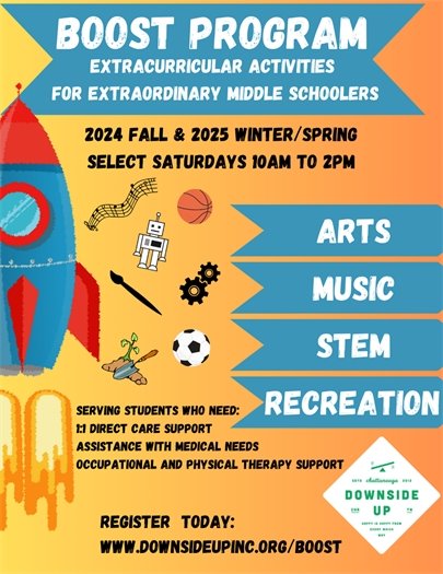
Programs and Projects Boost Program |
|
|
|
|
|
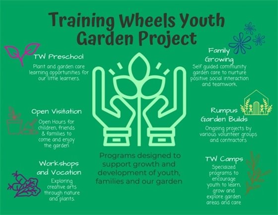
Training Wheels Preschool Program Training Wheels preschool program is a unique and individualized preschool experience for our young learners. Unlike most preschools, we are not devoted to a specific theory or approach when teaching Early Childhood Education. We believe in the power of play and utilize a combination of Montessori Techniques and Traditional Learning Approaches in our daily lessons. We simply meet the child where they are and nurture their own unique learning style. Our classroom is not segregated into age groups, children of ages 2.5 years to 6 years, and of all physical and intellectual abilities come together to play and learn. We pride ourselves on keeping our lesson plans play-based, hands-on and adaptive to each child's specific abilities and safety needs, all while introducing pre-kindergarten skills. Garden Project |
|
|
|
|
|
For more information, please contact Downside Up Inc. at: Address: 621 E 11th Street, Chattanooga, TN 37403 Mailing Address: P.O. Box 455, Hixson, TN 37343 Email: downsideupinc@gmail.com Phone: 423.803.6944 Website: https://www.downsideupinc.org/ ___________________________________________________________________________________________ |
|
|
|
Looking Ahead March 4th - Regular Commission Work Session - 5 PM Regular Commission Meeting - 6 PM
March 18th - Regular Commission Work Session - 5 PM Regular Commission Meeting - 6 PM
March 12th - Planning Commission Work Session - 12 PM March 26th - Regular Planning Commission Meeting - 6 PM ______________________________________________________________ |
|
|
|
|
|
|
|